
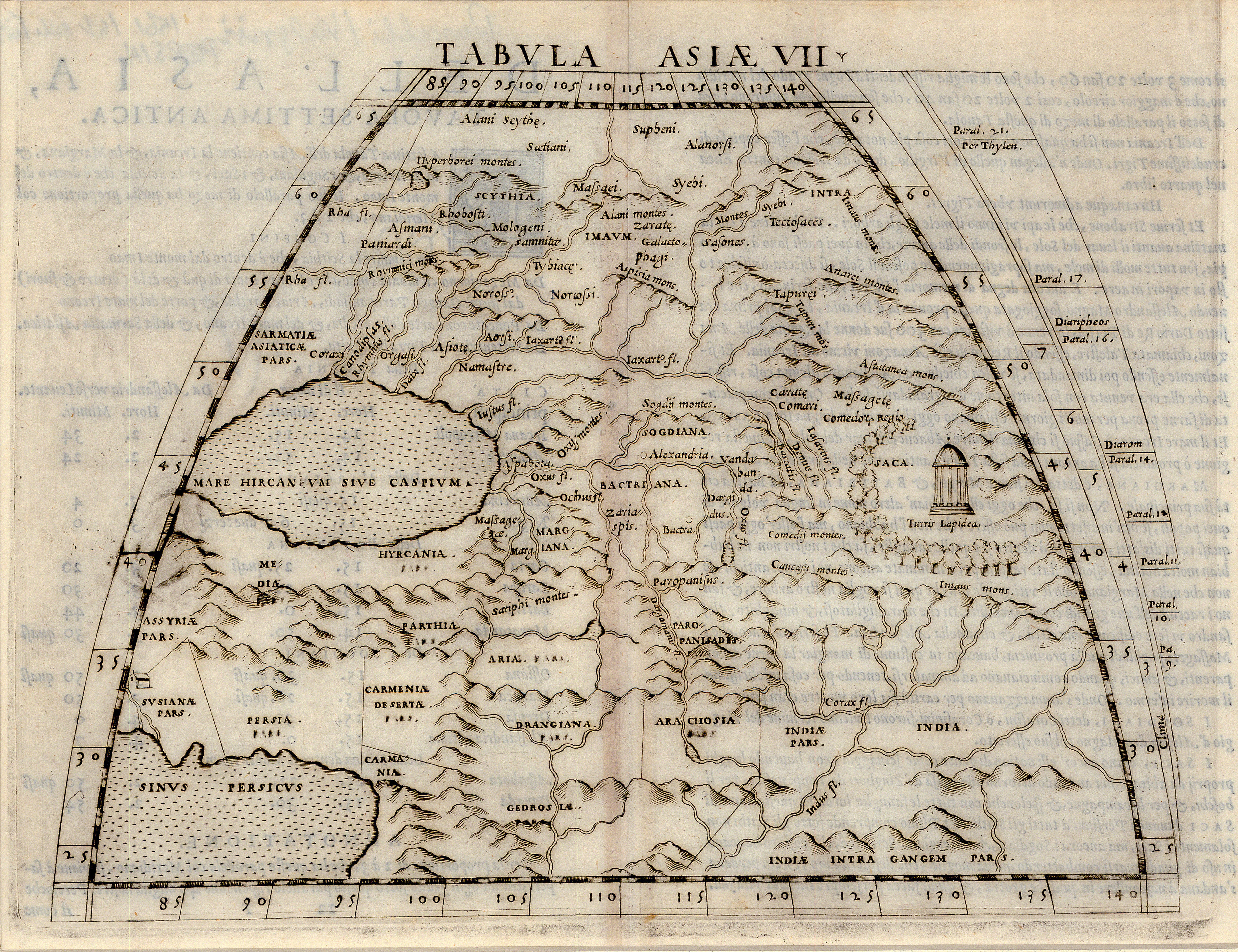
Tabvla Asiæ VII: Münster 1540 [1550]
- Title: Tabvla Asiæ VII
- Author: Sebastian Münster
- Date: 1540 [1550]
- Medium: Woodblock print
- Condition: Very Good - minor age toning and scuffing, light discoloration along issued center fold. Verso contains text to accompany map.
- Inches: 10 3/4 x 8 [Image]
- Centimeters: 27.31 x 20.32 [Image]
- Product ID: 222048
Born in Ingelheim, Germany to a family of farmers, Sebastian Münster (1488-1552) lived through the height of the Protestant Reformation. As a young man, he entered the Franciscan order, initially studying at university in Heidelberg under humanist and theologian Konrad Pellikan (1478-1556). Over the course of his studies at Heidelberg and various other German universities, Münster became friends with Martin Luther (1483-1546), and following his conversion to Lutheranism he accepted a position at the University of Basel in 1529. He would remain there for the rest of his life working as a professor of Hebrew, and gained a reputation as a highly-acclaimed scholar. Münster’s location in Basel (arguably the hub of Early-Modern intellectual activity) compounded with his humanistic inclinations brought him into contact with major reformers, academics, and theologians of the day, with whom he fostered lively academic exchange.
Münster’s first major cartographic work, a 1540 publication of Ptolemy’s Geographica, was the earliest description of the world printed in the German language. In addition to its Ptolemaic maps, Münster’s Geographica included several modern maps which depicted various regions of northern Europe and drew from the work of contemporary cartographers. The Geographica, distinguished by its instantly-recognizable woodcut maps, would be reissued several times over the course of Münster’s life. His second major work, the Cosmographica (1544), was enormously popular and remained in widespread use well into the seventeenth century. Published in six volumes with 471 woodcuts and twenty-six maps, the Cosmographica contained the first map to depict North and South America as a single landmass. This map of ‘Die Nüw Welt’ not only cemented European understanding of the continent by solidifying its naming as ‘America,’ but also stands as the first map to name the Pacific Ocean.
While Münster’s cartographical accomplishments would be eclipsed in subsequent decades by the work of Abraham Ortelius and Gerard Mercator, his maps served as important source material for later cartographers. He also achieved a number of cartographic firsts; in addition to producing the first modern atlas, he was the first to use separate maps for each of the four continents (America, Europe, Asia, and Africa).
Product Information
Product Information
Shipping & Returns
Shipping & Returns
Description
- Title: Tabvla Asiæ VII
- Author: Sebastian Münster
- Date: 1540 [1550]
- Medium: Woodblock print
- Condition: Very Good - minor age toning and scuffing, light discoloration along issued center fold. Verso contains text to accompany map.
- Inches: 10 3/4 x 8 [Image]
- Centimeters: 27.31 x 20.32 [Image]
- Product ID: 222048
Born in Ingelheim, Germany to a family of farmers, Sebastian Münster (1488-1552) lived through the height of the Protestant Reformation. As a young man, he entered the Franciscan order, initially studying at university in Heidelberg under humanist and theologian Konrad Pellikan (1478-1556). Over the course of his studies at Heidelberg and various other German universities, Münster became friends with Martin Luther (1483-1546), and following his conversion to Lutheranism he accepted a position at the University of Basel in 1529. He would remain there for the rest of his life working as a professor of Hebrew, and gained a reputation as a highly-acclaimed scholar. Münster’s location in Basel (arguably the hub of Early-Modern intellectual activity) compounded with his humanistic inclinations brought him into contact with major reformers, academics, and theologians of the day, with whom he fostered lively academic exchange.
Münster’s first major cartographic work, a 1540 publication of Ptolemy’s Geographica, was the earliest description of the world printed in the German language. In addition to its Ptolemaic maps, Münster’s Geographica included several modern maps which depicted various regions of northern Europe and drew from the work of contemporary cartographers. The Geographica, distinguished by its instantly-recognizable woodcut maps, would be reissued several times over the course of Münster’s life. His second major work, the Cosmographica (1544), was enormously popular and remained in widespread use well into the seventeenth century. Published in six volumes with 471 woodcuts and twenty-six maps, the Cosmographica contained the first map to depict North and South America as a single landmass. This map of ‘Die Nüw Welt’ not only cemented European understanding of the continent by solidifying its naming as ‘America,’ but also stands as the first map to name the Pacific Ocean.
While Münster’s cartographical accomplishments would be eclipsed in subsequent decades by the work of Abraham Ortelius and Gerard Mercator, his maps served as important source material for later cartographers. He also achieved a number of cartographic firsts; in addition to producing the first modern atlas, he was the first to use separate maps for each of the four continents (America, Europe, Asia, and Africa).


